
Support that doesn’t end at go-live

Live from day one. Productive for years
Support starts before go-live and does not stop afterward. Training brings your teams up to speed on their own data and workflows. Integrations connect the BeExact platform to the systems you already run. Tailor-made development covers the requirements specific to your organization, and hosting keeps the environment available, current, and secure, for as long as the network is in service.
Built for adoption, continuity, and change
Every engagement is built around your setup, your tools, and your long-term goals. Platform development continues throughout the contract, and improvements reach every customer, not a single installation. Service levels are agreed and measured. Information security is managed through a structured management system, and your data can always be exported in open, documented formats.
The business case for a long-term partnership
Adoption decides return on investment. A platform used at half its capability delivers half its value, and the gap is usually training and integration, not software. Support closes that gap and keeps it closed as your organization changes. Escrow and open export formats protect your continuity, so one partner covers the full lifecycle without leaving you dependent on circumstances you cannot influence.

“We were only using a fraction of the platform for the first year. Once BeExact retrained our planners on their own data, adoption changed almost overnight.” – IT lead, regional water utility

BeExact in action!
BeExact’s OnSupport continues well after go-live, keeping the platform delivering value over time.
Training, integration, and platform improvements are part of the ongoing partnership. Service levels are agreed and monitored, giving you a consistent standard to rely on.
That’s what turns a platform rollout into a long-term partnership.
Engineering that finishes what it starts

Engineering capacity that scales with your rollout
Rollout ambition is often limited by engineering capacity rather than by budget or demand. OnExecution supplies that capacity directly. Our engineering teams design FTTX, backbone, cellular, energy, gas, and water networks, and deliver the output your next step requires. A High Level Design gives you the costing and feasibility picture needed for an investment decision. A Low Level Design gives you construction-ready detail, complete with the documentation permitting authorities expect. Permitting is handled as part of the work, not left as your problem. One team, one point of contact.
Built for volume, compliance, and construction readiness
BeExact delivers an annual engineering capacity of more than 8 million homes passed. Designs are produced in the BeExact platform, so they inherit one flexible data model, automated clustering, and an accurate bill of materials rather than depending on individual drafting habits. Permit-ready documentation is prepared to the standard of the authority reviewing it, which avoids the resubmission cycles that quietly consume weeks. Field teams track progress in real time and feed as-built detail straight back into the record.
The business case for one accountable partner
Engineering demand in infrastructure is uneven by nature. Hiring for peak volume is expensive, and hiring after the contract is signed is too late. OnExecution gives you capacity that scales with the program, without permanent overhead, and quality that stays consistent from region to region. Because OnExecution connects to OnCapture, OnDetection, OnDesign, and OnWorkflow inside one ecosystem, you hold one partner accountable for the outcome instead of managing a chain of handoffs between vendors. One process, one standard, one point of responsibility.

“We stopped losing weeks to permit resubmissions once the documentation was built for the authority reviewing it, not just for us.” – Rollout director, energy network operator

BeExact in action!
BeExact’s OnExecution turns engineering capacity into a predictable resource for your rollout.
Every design ships with the documentation permitting authorities expect, so projects move to construction without resubmission delays. Field teams track progress against the design in real time, keeping the as-built record accurate as construction proceeds.
That combination gives program owners a single path from design to build, backed by one accountable BeExact team.
Every team, working from the same status
One process. Every team aligned.
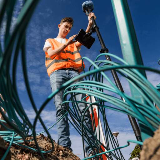
Rollout delays rarely come from a single failure. They come from handovers. A design leaves engineering, a task reaches a contractor late, an as-built record arrives weeks after the trench is closed, and the schedule quietly slips. OnWorkflow removes those gaps by running planning, engineering, and construction on one shared record. A web portal serves planners, service desk staff, and administrators, while a companion app serves engineers in the field, both working from the same live data: a change made on site is visible in the office immediately, and the other way around. Every address in the rollout area is tracked in one place, from contact details and documents to the status of every task. Every resident contact moment is logged on a call board, so an appointment is booked without switching between screens. Everyone works from the same status, so progress is a fact rather than a question.
Built for coordination, visibility, and control
TTask and resource planning stays synchronized across every project, with teams and subcontractors scheduled by drag-and-drop on a visual planning board instead of separate calls and spreadsheets. Task triggers update status automatically as work is completed, based on rules each contractor sets, so planners are not chasing every step by hand. A customer portal lets residents book their own appointment or complete their own inspection, within the windows the contractor allows. Field teams close the loop directly: mobile tools capture task completion, photos, and site detail as work happens, even without a connection, and sync back into the record the moment one returns. Dashboards and exports show what is open, planned, or completed, by project, team, or area, on demand. Because OnWorkflow connects to OnDesign and OnExecution inside the BeExact ecosystem, a design change reaches the field and a field change reaches the design without anyone rekeying data.
The business case for one connected rollout
Rework is the most avoidable cost in infrastructure delivery, and most of it starts with information that was correct somewhere else. One connected process removes that failure mode. Automatic status updates and a shared live record cut the calls and emails needed just to find out where a task stands. Drag-and-drop scheduling gets teams and subcontractors planned faster, and a self-service customer portal cuts no-shows by letting residents pick a slot that actually works for them. As-built records keep pace with construction instead of trailing it, which shortens acceptance and speeds up invoicing. Because each contractor configures their own workflow without losing operator-wide oversight, the platform scales from one project to a national program without losing grip on any of them.
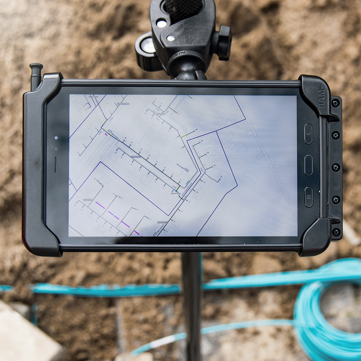
“Our subcontractors used to call the service desk to check what they’d been assigned. Now they open the app and it’s already there, updated, with nobody in the office having to touch it.” – Rollout program manager, infrastructure contractor
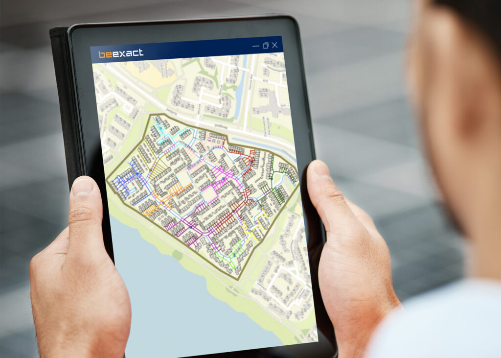
BeExact in action!
BeExact’s OnWorkflow keeps every team working from the same live record, from planning through construction.
Field updates reach the office the moment they happen, so status reflects what’s actually happening on site rather than what was reported last. Automatic task triggers and self-service appointment booking remove the calls and emails that usually fill a planner’s day.
The result is a rollout that moves at the pace of the work itself.
Precision that doesn’t slow you down
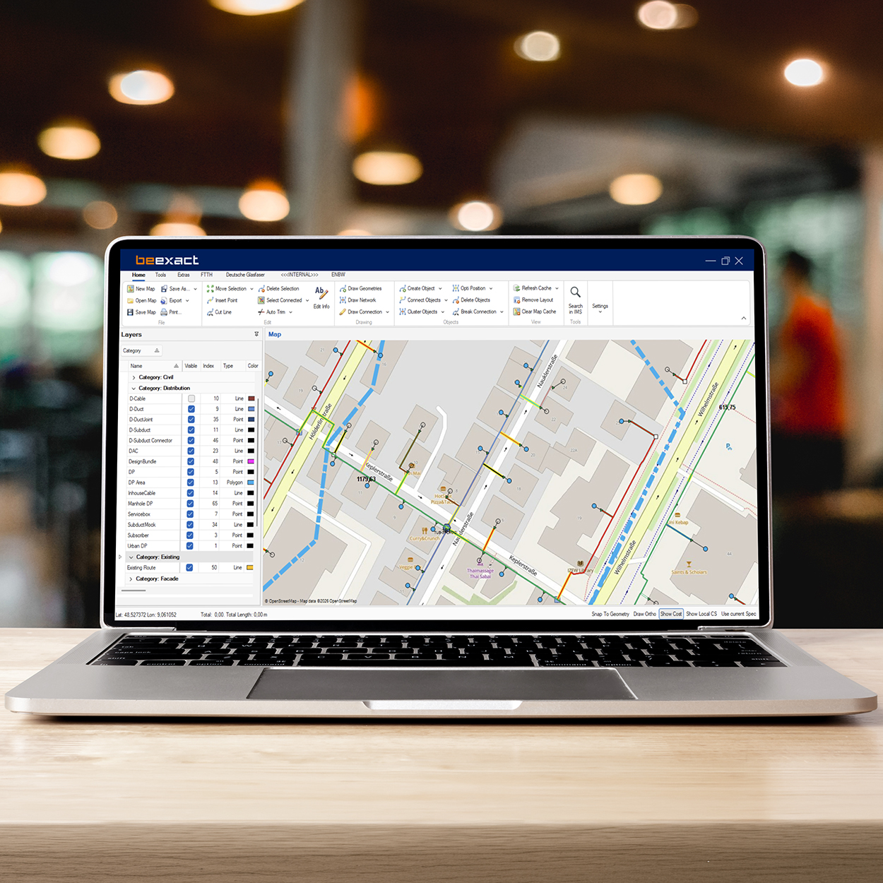
One platform. Every network decision
Every network rollout starts with a decision that shapes years of cost, performance and reliability: how the network gets designed. Infrastructure Design Software, part of the BeExact ecosystem, replaces scattered spreadsheets, disconnected GIS tools and manual clustering with one flexible data model built to configure any existing or future network. Fiber, energy and utility operators use the same platform to move from high level costing to construction ready detail, without switching systems or entering data twice. Built on more than twenty five years of network engineering experience, it turns GIS and CAD into one connected environment, so every design decision is grounded in real data captured in the field, not assumptions made at a desk. One source of truth, from first sketch to as-built record.
Built for speed, precision and scale
One flexible data model underpins every tool in the platform, so network, GIS and CAD information live in a single, always current database instead of scattered files. Built in clustering algorithms calculate the most cost-efficient routes and node placements automatically, generating an accurate bill of materials and a fully engineered network in minutes rather than weeks, with a high-level design for 1,000 homes possible in under 20 minutes. Task and resource planning stays synchronized across every project, so schedules, crews and progress updates never fall out of step. Field teams close the loop directly: mobile tools capture GPS positions, redlines and as-built detail on site, syncing straight back into the design, even offline. Once a network is live, the same platform supports outages, capacity checks and expansions, keeping design and operations on one continuous record.
The business case for one connected process
The payoff shows up on the balance sheet as much as on the map. Projects land on time and within budget, with cost per home projections accurate enough to trust at the business case stage. Centralized quality control and shared best practices replace inconsistent, ad hoc engineering, while automated clustering and planning let existing teams take on more projects without adding headcount. Comprehensive as-built records mean fewer surprises during construction and faster, cheaper maintenance for years afterward. Because design connects directly to the rest of the BeExact ecosystem, from field capture through workflow and execution, network operators, utilities and engineering firms get one accountable process instead of a chain of handoffs, and one place to see exactly where every project stands.
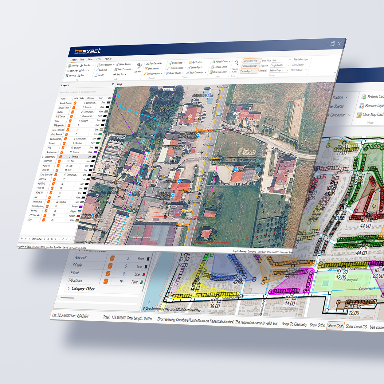
“We used to redesign a route three times before it ever reached construction. Now the first design is usually the one we build.”
– Network design lead, fiber network operator
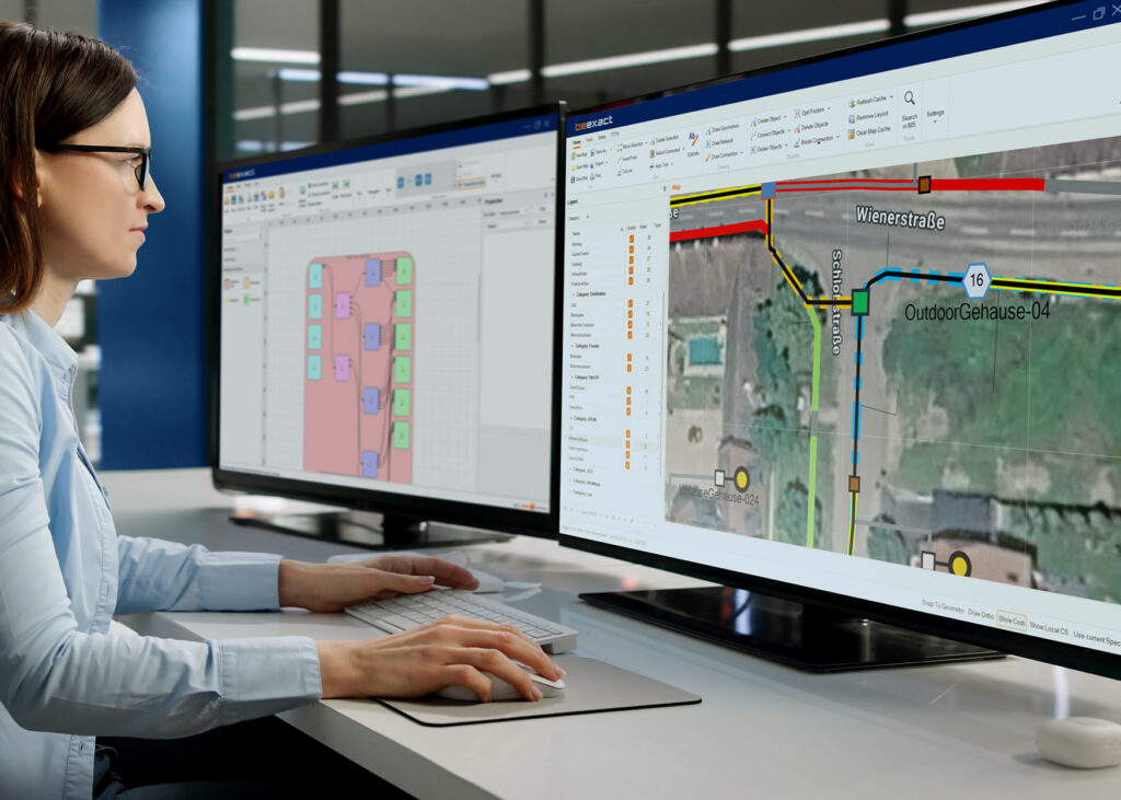
BeExact in action!
BeExact’s OnDesign turns a design into a plan that survives construction without rework.
Automated clustering turns a High Level Design for a thousand homes into a finished plan in under twenty minutes, complete with an accurate bill of materials. Field data feeds straight back into the same model, so every update stays grounded in what’s actually in the ground.
That accuracy is what lets the first design become the one that gets built.
Intelligence that gets sharper with every scan
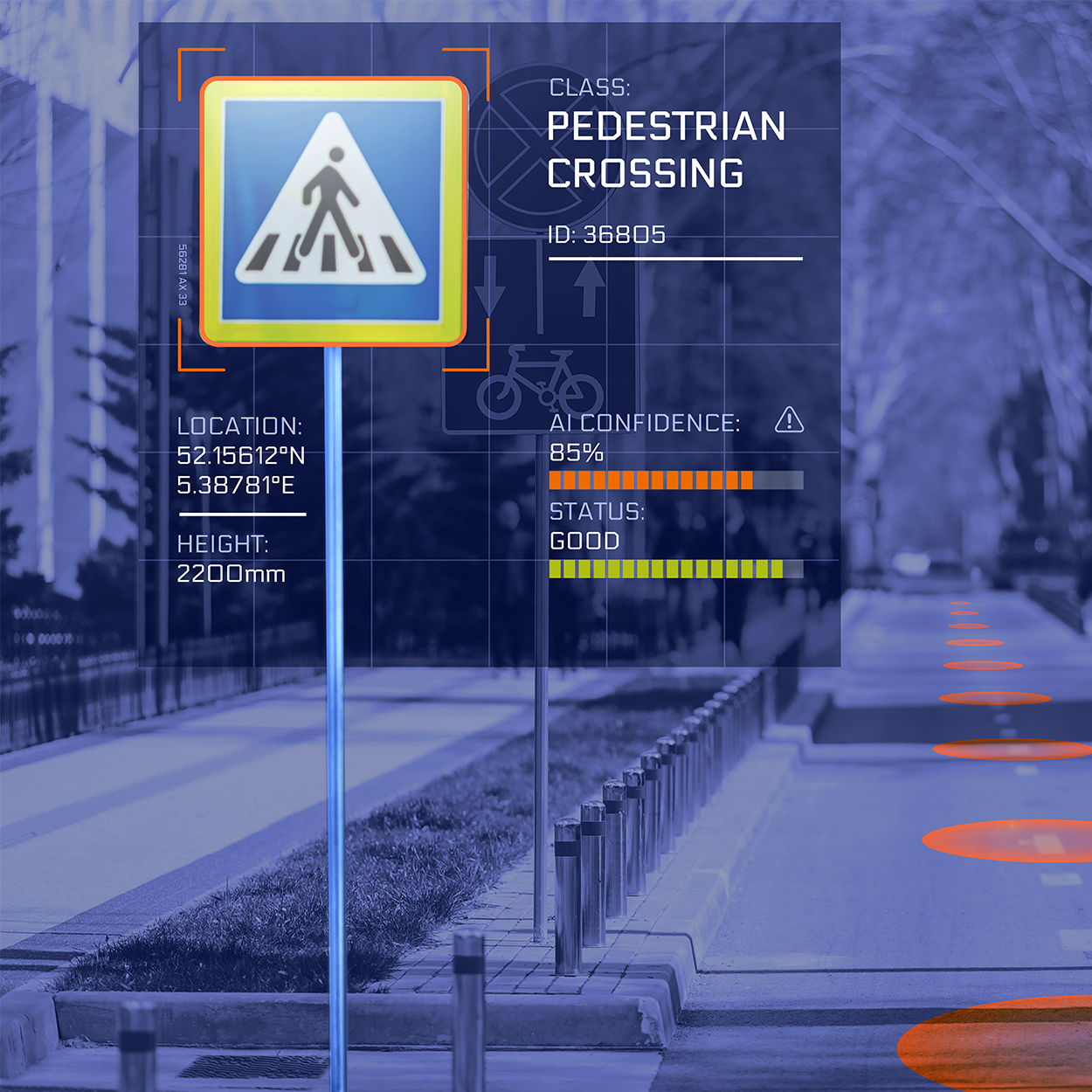
From raw data to network intelligence
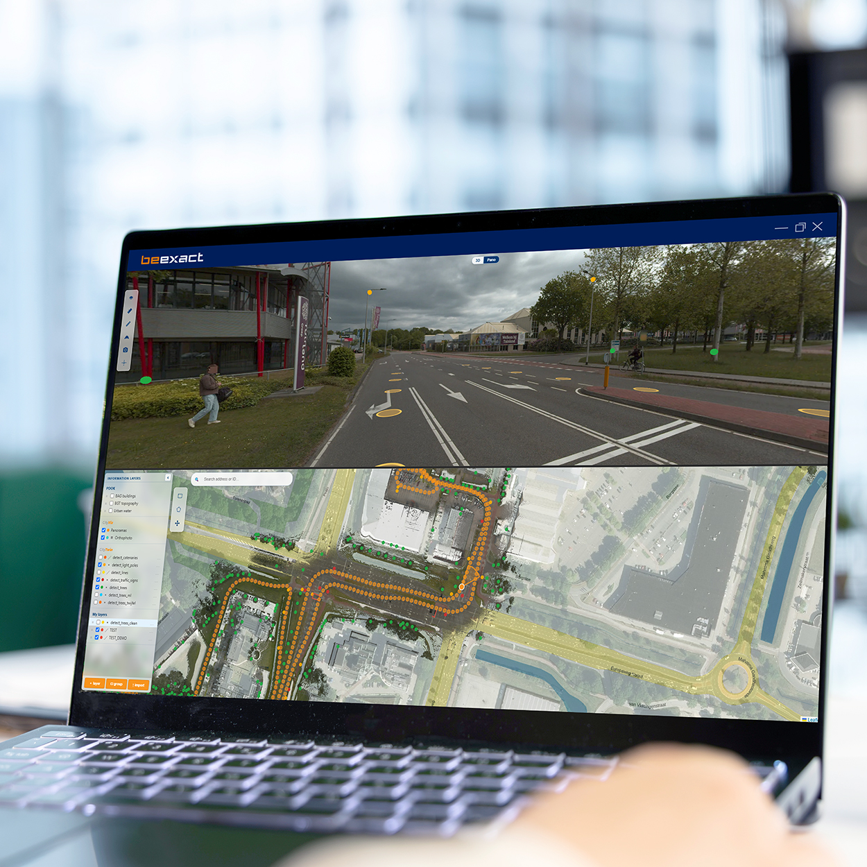
Captured data is only valuable once it becomes information you can act on. OnCapture delivers the imagery and point clouds. OnDetection interprets them. AI models identify and classify assets across the full survey area, then place each object on the map with a coordinate you can use. Address validation checks and completes address data at scale. Road surface analysis and ground cover analysis grade condition and material across the network. Point cloud processing turns raw measurement into structured geometry for GIS and engineering. Our Smart Viewer 360 brings imagery, point cloud, map, and detection layers into one screen, where a click in one view synchronizes the others to the same location. Detection layers are separated per source, so your own data, national reference layers, and AI results stay distinguishable at all times.
Built for consistency, coverage, and scale
Manual inspection samples. Detection covers everything. The same models are applied to the whole survey area, which means every street is assessed against the same standard on the same day. Address validation reaches more than 98% accuracy, and CapEx calculations built on detected data reach 97% accuracy. Detected objects, including trees, light poles, traffic signs, and street furniture, appear directly in both the panorama and the map view. Detection models are retrained continuously as new data arrives, so accuracy improves across the platform rather than per project. A built-in mutation comparer sets one capture year against another, so change between periods is visible without a manual comparison exercise.
The business case for automated detection
Cost certainly starts earlier than most teams expect. When asset and address data is validated up front, cost per home projections become accurate enough to trust at the business case stage, before commitments are made. Consistent standards replace individual judgment, which removes the variation that makes network data hard to compare between regions and contractors. Teams prioritize on evidence, targeting the assets and areas that need attention first. And because detection runs on data you already own, existing surveys keep producing new insight without new fieldwork.
“Our CapEx estimates used to move every time a new survey came in. Now the number holds from business case to construction, because it was validated the first time.” – Head of network investment, fiber network operator

BeExact in Action!
BeExact’s OnDetection turns every survey into validated, decision-ready network data.
Address and asset detection reach accuracy above 97%, so cost projections hold from business case through construction. The same models assess every street to the same standard, giving teams a consistent basis for comparing regions and contractors.
That consistency lets planners act on evidence from day one.
Real-world accuracy, captured once

One pass through the field. Every dataset you need
Every infrastructure decision depends on knowing what is actually there. OnCapture records the physical environment once, then turns it into a dataset your whole organization can use. Mobile mapping vehicles collect 360-degree panoramic imagery and LiDAR in the same moment, so imagery and point cloud share one trajectory and one coordinate framework. Drone scan reaches what a vehicle cannot. Backpack and indoor systems handle dense urban environments, buildings, and sites without road access. Ground scan uses ground penetrating radar to map what sits below the surface. GPS survey anchors everything to the national reference system. The result is one geometrically consistent record of public space, ready for design, permitting, inspection, and asset management. As part of the BeExact ecosystem, that record flows straight into OnDetection, OnDesign, and OnExecution without a handover or a reformat.
Built for coverage, accuracy, and repeatability
BeExact operates more than 90 mobile mapping systems and has captured more than 60 million homes passed. Programs at national scale are routine work for our teams. Coverage is complete rather than sampled. Every road, square, cycle path, foot path, and public parking area in the survey area is recorded, and divided roads are driven in both directions, so nothing stays hidden behind a central reserve. The same method is applied everywhere, which makes results comparable between regions and between capture years. Accuracy is verified automatically on every project before delivery, and each delivery includes an accuracy report covering the full survey. Faces and license plates are masked automatically, immediately after capture, so privacy is handled at the source. You receive a dataset your teams can use straight away, and one that holds up to scrutiny from regulators and the public.
The business case for fewer site visits
Site visits are the most expensive way to answer a simple question. One systematic capture replaces many individual trips, and the same dataset serves design, permitting, inspection, maintenance, and asset management. Every team works from one source, so nobody drives out to verify what a colleague already recorded. Ground scan reduces the risk of excavation damage, which protects crews and removes one of the most common causes of unplanned cost in construction. Most cities and network operators now capture once a year, which keeps the record current while field trips stay the exception. You put fewer vehicles on the road, spend fewer hours in the field, and lower the cost of every decision that used to require a visit. That saving returns with every capture cycle.

“We used to send an inspector out every time a design question came up. Now the answer is already in the platform, and the accuracy report holds up when a permit gets challenged.” – Network planning lead, regional grid operator

BeExact in Action!
BeExact’s OnCapture replaces recurring site visits with one dataset every team can rely on.
More than 90 mobile mapping systems have captured over 60 million homes passed, each project delivered with a full accuracy report. Design, permitting, inspection, and maintenance all draw from that same record, so one answer serves every team.
That reliability turns a single annual capture into a year of confident decisions.